Carter County may need to prepare for ‘winterlike’ conditions on Halloween
Published 8:46 am Thursday, October 30, 2014
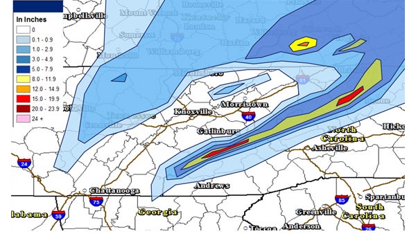
Graphic courtesy of National Weather Service
According to a forecast issued Wednesday by the National Weather Service, a strong upper level storm system will move into the region late Friday through Saturday, bringing with it the potential for “significant snowfall.”
Mother Nature may be handing out tricks instead of treats Halloween night as the National Weather Services is forecasting a winter storm with the potential to bring “a significant snowfall” in Northeast Tennessee.
“We will be in for a big change for the weekend,” said David Gaffin, a forecaster with the NWS. “It’s going to get colder for Halloween, especially Friday night.”
According to the forecast issued Wednesday by the NWS, a strong upper level storm system will move into the region late Friday through Saturday. The system will bring a “winterlike” chill to the area for the weekend, the forecast said, adding that widespread rain showers will develop by late Friday afternoon and evening, changing to snow as cold air moves into the area.
Lower elevations could see up to an inch of snow from the winter storm, but higher elevations could see greater accumulations, Gaffin said.
“Up in the mountains you could see several inches of snow,” Gaffin said. “It could be a significant snowfall.”
On Wednesday afternoon, the NWS issued a “Hazardous Weather Outlook” for the region in connection with storm, saying heavy wet snow accumulations are possible, mainly across the higher elevations, especially at elevations above 2,000 feet. A forecast map shows snowfall estimates ranging between 1 and 5 inches for much of Carter County, with the possibility of 8-20 inches in the Roan Mountain area, but the NWS said “exact accumulations are uncertain at this time.”
Gaffin said temperatures for the weekend will be below normal for this time of year. The forecast high for Saturday is 39 degrees. Gaffin said that temperature is “15-20 degrees below normal,” adding normal highs for this time of year average in the lower 60s while lows typically range in the upper 30s.
“I consider this to be early to see a snowfall, but it is not unusual or too rare,” Gaffin said.
According to the forecast, Thursday is expected to be sunny with a high of around 57 degrees and temperatures dropping into the upper 30s overnight. Friday morning starts out with a 20 percent change of showers during the day and a predicted high of 54 degrees. Friday night will see temperatures fall into the lower 30s with a 70 percent change of precipitation which will begin as rain and change into a mix or snow. The high for Saturday is only expected to reach 39 degrees with a 70 percent change of precipitation in the form of rain or snow, depending on location. Saturday night the temperature drops down into the high 20s with a 60 percent chance of snow. The weather warms up slightly on Sunday with a forecast high of 48 degrees with mostly sunny skies.
The cold weather predicted for this weekend could bring an end to the fall foliage season. Great Smoky Mountain National Park is reporting this week should be the peak for fall leaves. Great Smoky Mountains Guide, a tourism website, has been following the changes in the fall colors and reports the colors will peak this week in East Tennessee. “The sunny days have made the fall foliage show this year slow to progress but the colder temperatures expected by this weekend with frost and freezing night time temperatures may bring the show to a halt if the freeze causes the leaves to quickly fall off,” the website said.
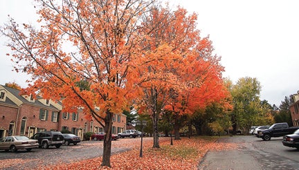
Photo by Brandon Hicks
Fall foliage colors are at their peak this week, but a winter storm forecast for this weekend could bring the colors to a halt.