Keep little ghouls safe tonight – watch for trick-or-treaters, prepare for bad weather
Published 9:03 am Friday, October 31, 2014
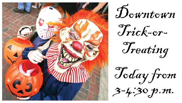
Star File Photo
Evan Rogers, 7, and Shyann Rogers, 9, trick-or-treat downtown last year. This year’s downtown Elizabethton trick-or-treat event is 3-4:30 p.m. today. Those planning festivities for the holiday are advised to keep an eye on the weather as a winter storm is forecast to move into the area this evening.
As ghouls and goblins prepare for tonight’s festivities, police are reminding trick-or-treaters to stay safe as they make their rounds.
This year is the first time in several years that Halloween has fallen on a Friday, and Elizabethton Police Department Chief Greg Workman said that could mean a larger turnout of children, as well as more traffic on highways and city streets.
“Slow down, especially if you are going through neighborhoods,” Workman said, adding drivers should be “extra conscientious” in watching for children crossing the street, especially for children who may dart out between parked cars. He also recommends drivers travel below the posted speed limit in residential neighborhoods.
Workman suggested that trick-or-treaters carry flashlights, wear reflective clothing and travel in groups with their friends.
“Don’t go to strange neighborhoods or places you haven’t been before,” Workman said. “Make sure your parents check your candy before you open it up.”
A safe way for children to participate in Halloween activities, Workman said, is to take part in the Elizabethton Downtown Business Association annual trick-or-treating event, which will be held 3-4:30 p.m. today. The event also will feature games and inflatables sponsored by the Elizabethton Parks and Recreation Department.
In addition to keeping safety in mind, children and parents should keep an eye on the weather today. The National Weather Service has issued a Winter Storm Watch for the area as a front moves in, bringing with it rain, colder temperatures and the potential for a significant snowfall.
A forecast issued by the NWS office in Morristown predicts today’s high temperature will be 57 degrees with a 40 percent chance of rain. As the day transitions into evening, rain could mix with or turn into snow as colder air moves in, and the chance for precipitation will increase to 90 percent.
Lower elevations might see up to 2 inches of snow, but higher elevations, mainly above 2,500 feet, could see a foot or more.
“At this point in the forecast, Carter County is almost split in half by the projected snowfall amounts,” Carter County Emergency Management Agency Director Gary Smith said. “The south and east part of the county can expect between 6 and 15 inches of snow. The altitude is going to determine how much any specific area gets. The higher the altitude, the more you can expect, so the higher areas of Roan Mountain such as Carver’s Gap are expected to see upwards of 15 inches of snow.”
The north and south parts of the county could see up to 2 inches, he said.
Friday’s low temperature should be in the low 30s, with Saturday’s high in the low 40s. According to the forecast, Saturday will see a 90 percent chance of precipitation in the form of rain and snow with the chance of snow carrying over into Saturday night.
Trick-or-treaters should dress for the weather, and motorists should prepare for deteriorating road conditions as the rain turns to snow Friday night.