SAHC acquires 52 acres near Carvers Gap
Published 12:16 pm Tuesday, April 4, 2023
|
Getting your Trinity Audio player ready...
|
CONTRIBUTED BY ANGELA SHEPHERD
Persistence and patience reside at the core of conservation. Sometimes Southern Appalachian Highlands Conservancy (SAHC), our partners, and/or landowners may not be in a position for permanent protection of a high priority parcel to move forward for years – perhaps even decades.
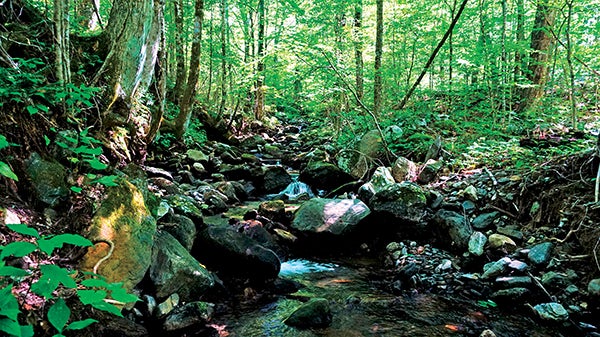
Such was the case with the 52-acre parcel on Toms Branch that SAHC recently purchased in the Highlands of Roan. Located off TN Highway 143 and adjoining Cherokee National Forest just north of Carvers Gap, the property is highly visible to hikers on the Appalachian Trail at Round Bald and Jane Bald. Its location, and the protection of water quality in Toms Branch, meant that it had been a conservation priority for SAHC, the U.S. Forest Service and the Appalachian Trail Conservancy for 40 years.
“When the first focus area maps for what became the Southern Appalachian Highlands Conservancy were drawn in the 1960s, high priorities were given to protection of the Appalachian Trail and its viewshed, high elevation tracts where threatened and endangered species were known or suspected, and tracts where development could compromise these attributes and mar the landscape,” says former SAHC Trustee and Board President Joe DeLoach. “In much of the Roan Massif the 4,000-foot elevation contour served as the general boundary, with tracts prioritized as our assessments became more refined. At least 40 years ago the headwaters of Toms Branch, high on Heaton Ridge along TN Highway 143, received such a priority. These lands reach to 4,400′ elevation and contain pristine headwaters of Toms Branch, itself one of the headwaters of the Doe River flowing cold and clear through Roan Mountain State Park. Their proximity to TN Highway 143 made them quite developable, and as the highest elevation private land along the highway such development would have been very visible both from the valley below and the mountain crest. It is a joy to see these lands preserved after so many years of effort. Many good adjectives can be used to describe SAHC, but none fit better than perseverant!!”
“This is a case where SAHC took out a loan to secure a long-time priority for conservation, and will hold it until the U.S. Forest Service can acquire it from us, which will enable us to repay the loan,” elaborates Executive Director Carl Silverstein. “We are really in the midst of this transaction – we have saved the property from immediate danger of development, but putting it into the hands of the public will take some additional time and funding. We are thrilled to celebrate this stage now, and look forward to celebrating the transfer when that happens.”
The tract adjoins Cherokee National Forest, and SAHC plans to transfer it to the U.S. Forest Service to become part of the national forest.
“Because of its location, acquiring Toms Branch will have an outsized impact on protecting the southern Appalachian strain of Brook Trout,” says Cherokee Forest Supervisor Mike Wright. “SAHC has been a key partner to the Cherokee National Forest and we are grateful for their hard work on this.”
The Overmountain Chapter of Trout Unlimited contributed a $6,000 donation towards the protection and stewardship of the Toms Branch tract.
“The Overmountain Chapter Trout Unlimited is excited to partner with SAHC to protect the headwaters of the Doe and Watauga Rivers,” says Rhett Morris, chapter president. “Keeping these waters clean and cold will benefit trout and downstream communities for years to come. We are thankful for donors like the Tri Fly Tournament that make our support possible.”
Over decades, staff from SAHC built long-term relationships with landowners in the region, demonstrating a commitment to conservation and patience in establishing connections with people who have loved and lived in the region for generations.
“This has been a priority as long as I’ve worked with SAHC,” adds Associate Director Kristy Urquhart, who is in her 32nd year with the organization. “This is really an historic conservation success story. Many folks have been involved over the years in trying to protect this property and other priority tracts, including people who have retired or passed on. This acquisition is not just important to us, but to the people who came before us and those who will come after us. It’s an intergenerational story.”
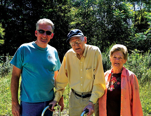
Landowner Perspective: Wanda and Scott Greer
When Wanda Greer’s husband C.L. (Clayton Lloyd Greer) passed away last year, her son Scott helped her with the difficult process of scaling back, simplifying, and moving to live closer to family. Part of that process involved selling the 52-acre Toms Branch tract off Highway 143, just north of Carvers Gap in Carter County, Tenn.
C.L. was born in 1931 in the Burbank Community of Roan Mountain to John and Melissa “Lissie” Troutman Greer (“Pop” and “Mom” Greer). “The property was passed down by my husband’s parents,” says Wanda Greer. “We had talked with Carl at SAHC about conserving the land several years ago, and I’m really happy that the conservancy was able to buy it. We couldn’t afford to donate it – but I’m happy to have it conserved because it will always be there for the public to walk and hike on. I’d much rather see that than have it developed.”
“Dad had a lot of memories of time on the property,” says Scott Greer. “My grandparents owned the property when I was growing up, and I loved it as a kid. I remember as a boy of 10-13 years old going there to pick apples, playing, and climbing. It was a great place to adventure. In the early 1900s, there was an old residence on the property where my grandparents once lived, but it was long gone. They had moved a little further up Burbank Road, and I would go visit the Toms Branch property from my grandparents’ home – hiking across the fields and scrambling down a steep embankment to reach it. It was an adventure just getting there in the first place. We would cross the creek and look for crayfish and trout in the stream. When my father was growing up, his parents still used the Toms Branch property for farming, gardening and apples. The lower part of the land was clear at that time, and an old barn still stood there.”
Wanda remembers that the old barn was made of wormy chestnut wood, which was taken down at some point and the wood repurposed by someone else. She says there used to be a lot of American chestnut trees in there, and C.L.’s father remembered when they started dying out. The family also used the tract for hunting and spent many summers camping and hiking across the Roan Highlands.
“We heard the story from Pop Greer that they lived at one time in a small house there, and their second child was born there,” shares Wanda. “That property, with the old homeplace, had been split off of a larger piece that Mom Greer’s family owned. Mom and Pop Greer had some interesting stories to tell. The Old Hackline Road ran from Burbank to the top of Roan Mountain, and they operated a toll gate on the road, which was once used to access the Cloudland Hotel. It was called the “Hackline Road” because someone at the bottom in Roan Mountain ran a hack – a small wagon or “horse-drawn taxi” – and would pick up people there to take to the top of the mountain. Some would ride the train from Elizabethton to Roan Mountain before heading to the mountain. C.L. was just a boy when they opened the toll gate; by that time the hotel was gone, but people used the road to get to the top of the mountain for sightseeing. The Greers would put Cokes in cold springhouse water and C.L. would sell them to the people coming up the mountain to make some spending money. Mom and Pop Greer had an old timey telephone hanging on the wall, and there was another phone up at Carvers Gap. They would call to communicate back and forth to manage the toll gate. This was before Hwy 143 existed. Mom Greer was a good cook, too, and she liked to take care of people. Once, J.C. Penney came through going to the top of the mountain, and he stopped in at the Greer house for dinner and some good conversation.”
The property reaches up to TN Highway 143. When C.L. Greer graduated Cloudland High School in 1950, his first job was working on construction of the new Hwy 143, leading to the top of Roan Mountain. In fact, if you’ve driven to the Roan or anywhere around East Tennessee, you’ve surely set foot – or tire – on roads that C.L. Greer helped create. After 36 years of service, C.L. retired as a Superintendent from Summers Taylor, Inc. in 1996.
“He loved it, and he was so dedicated to his job,” says Wanda. “He had a hand in many roads that you drive on in East Tennessee and North Carolina.” Now, his legacy – and the family history which spans from Buladean, N.C. to Elizabethton, Tenn. – is also bound up in the protection of mountain habitat and scenic views from Highway 143 and the Appalachian Trail.
“We didn’t want to see the property developed in a drastic way, which would have disrupted the surrounding area,” adds Scott. “The family has grown up there, enjoying many years and memories camping on the Roan every summer, and we want to see the natural beauty of the area preserved. We still enjoy hiking the Appalachian Trail and other areas in the Roan Highlands. My parents had considered some options to sell the land years ago, but decided to hold into it. When the time came and they decided to finally sell it, they were happy to be able to come to an agreement with SAHC to purchase the land as one connected property and not have to break it up.”


