Snow to come earlier, be heavier than previously expected
Published 1:27 pm Wednesday, February 25, 2015
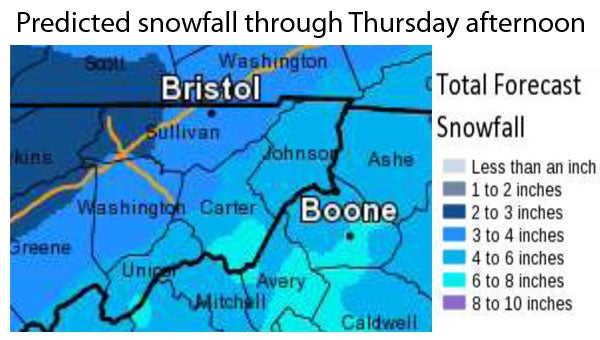
Graphic courtesy of the National Weather Service
An updated forecast from the National Weather Service predicts that tonight’s snowfall will begin earlier and be heavier than previously expected.
On Wednesday morning, Carter County Emergency Management Agency Director Gary Smith received the updated forecast from the National Weather Service office in Morristown.
“As often happens when dealing with weather, things have changed,” Smith said. “The most significant changes for us have to do with the expected snow totals. The Northwest section of Carter County is now expected to get 3 to 4 inches, the middle part of the County should see 4 to 6 inches, and the higher elevations, Roan Mountain, are forecast to get 6 to 8 inches.”
A Winter Weather Advisory is in effect from 4 p.m. today until 7 a.m. Thursday for Elizabethton, and a Winter Weather Warning is in effect for the higher elevations of Carter County during that same time frame.
“I would anticipate it getting to Carter County around 6 or 7 p.m., with the heavier accumulations starting at around 8 p.m.,” NWS forecaster Derek Eisentrout said. When the system first moves into the area, the snowfall will melt, but within about an hour of the snow’s arrival, it will begin to accumulate, he said.
“The heaviest accumulations will be from 8 p.m. until about 3 a.m.,” Eisentrout said. Snowfall will be possible after 3 a.m. as the system moves out of the area, but precipitation should diminish, he said.
The snow accumulation from the system that passed through Tuesday took many by surprise as significant accumulations had not been forecast.
“Fortunately, we have some lead time with this storm so, we can prepare,” Smith said. “Make sure you have your emergency kits restocked with food, water, flashlights and batteries. Also, don’t forget to charge the cellphones and other gadgets.”
“It’s also a good idea to have a full tank of gas in case of an emergency or delay getting to your destination.”
The snow for this system is expected to be wetter and heavier snow than Tuesday’s snowfall.
“If that is the case, there is the possibility of downed trees and power lines. So, make sure you have things in order just in case the power does go out,” Smith said. “If you have a secondary heat source, make sure it’s ready to go. If you don’t have another way to heat your home, make sure you have blankets and warm clothes available.”
“The temperatures are going to be colder, but not as bad as last week,” he said. “Regardless, hypothermia has claimed several lives in several counties in Tennessee as a result of this storm, so preparation will certainly help you survive.”
Road conditions are expected to deteriorate as the storm system moves in, leading to dangerous travel conditions tonight and into tomorrow morning.
“Roads will probably be slick, so travel could be hazardous in the morning,” Smith said. “Be careful and allow extra time tomorrow if you must travel.”
“This storm, or series of storms, has resulted in over 27 fatalities in Tennessee thus far,” he added. “Please take the time to make sure you and your family are prepared. We don’t want any more fatalities.”
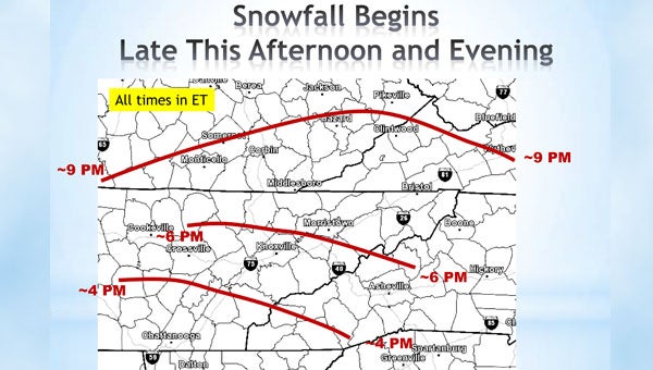
Graphic courtesy of the National Weather Service