February’s over, but winter is hanging on
Published 8:02 am Wednesday, March 4, 2015
Don’t put away those snow shovels just yet, Carter County. More of the white stuff may be on its way.
The area should see a lot of rainfall today, the National Weather Service said. Temperatures then are expected to drop tonight as a mass of cold air moves in behind the weather system, NWS forecaster Derek Eisentrout said Tuesday.
“You could start to see the possibility of some wintry precipitation Wednesday night into Thursday morning,” Eisentrout said. “There will be a little bit of freezing rain and a little bit of sleet mixed in there as it begins to transition.”
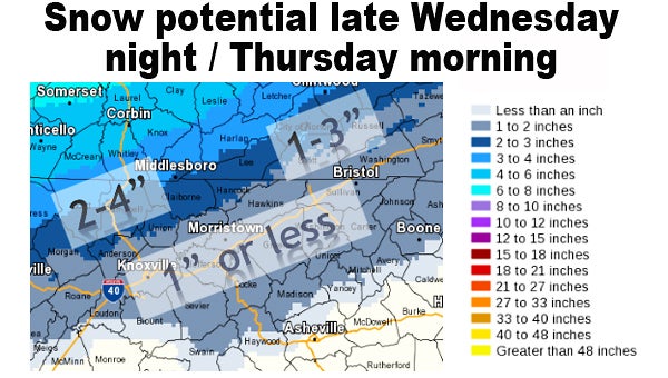
The rain will begin turning into sleet and freezing rain around midnight Wednesday before turning over into a “wintry mix” between midnight and 3 a.m. Thursday, Eisentrout said. After 3 a.m., the forecast calls for snow, he said.
Snow will continue to fall Thursday morning and will begin tapering off around noon, Eisentrout said. “Nonaccumulating snow showers will continue throughout the day until around sunset,” he added.
While the forecast does include the potential for sleet and freezing rain, Eisentrout said there would be little to no accumulation of ice across the forecast area. The same cannot be said for the snowfall, he added.
“It looks like accumulations in Elizabethton are expected to be about an inch or less,” Eisentrout said. “The higher elevations of Carter County, such as Roan Mountain, could see as much as 3 inches.”
Because weather is an ever-changing thing, Eisentrout said forecasts are always subject to change, especially when dealing with accumulation totals and predicted storm arrival times.
The high Tuesday should be about 63, with a low Wednesday morning of about 33. On Thursday, the high should reach 35 degrees before dropping to 16 degrees Thursday night.
With the chance for snow, sleet and freezing rain on Thursday morning, residents are warned that road conditions could deteriorate as the storm system moves through the area.
“The biggest thing is Thursday morning they are expecting there to be some travel issues,” Carter County Emergency Management Agency Director Gary Smith said. “Please plan accordingly and allow a little extra time for travel.”
On Tuesday afternoon, Smith took part in a weather briefing with the National Weather Service regarding the expected weather system. “They indicated in the briefing today that they did not have a high level of confidence in the time line,” Smith said, adding he was told the storm could arrive earlier or later than currently forecast.
“The big thing that concerns me is the ice that is supposed to move through first,” Smith said. Snowfall on top of any ice accumulation could prove dangerous for motorists, he said.


