Weather creates road hazards on Wednesday; Forecast calls for more snow this weekend
Published 9:56 am Thursday, January 21, 2016
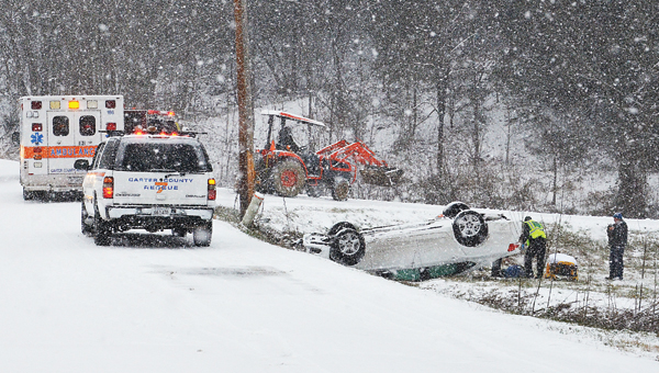
Star Photo/Rebekah Price
Though schools were called off in the county and city systems, Carter County emergency responders had no snow day off. Off Piney Flats Road in Watauga, a car with two passengers slid off the road and upside down, injuring its two passengers. One woman experienced a neck injury and the other was wheeled to the ambulance with a back injury.
Snow fell across the area for much of the day on Wednesday creating hazards for motorists.
Several motor vehicle accidents were reported around the city and county on Wednesday.
A section of Highway 321 near the Little Stoney Campground was completely shut down Wednesday afternoon as the Tennessee Highway Patrol investigated an accident involving a tractor-trailer truck that jack-knifed in a steep curve on the highway.
The northbound lanes of Highway 19E near the Lighthouse for Jesus church were closed for a while during the afternoon due to several vehicles running off the roadway in the curve near the church.
Around 5 p.m. emergency crews were dispatched to a wreck on Highway 19E in Hampton at the double bridges after a vehicle was reported to have struck the wall of one of the bridges.
Harzardous conditions were also reported on Highway 67 between Elizabethton and Johnson City as well as on Mary Patton Highway near the intersection with Gap Creek Road.
While some residents may have gotten their fill of the fluffy white stuff, winter weather is not out of the forecast yet.
Though today was supposed to bring a slight increase in temperatures along with a chance for rain, the National Weather Service is predicting a severe winter storm for the area beginning on Friday and carrying through the weekend.
Snow will move back into the area on Friday, said NWS Meteorologist David Holtz.
“We’re still a little ways off to know the exact amounts but for the City of Elizabethton we are looking at the possibility of anywhere from four to nine inches,” Holtz said, adding there is the potential for more snow fall in the higher elevations. “Roan Mountain could definitely see up to a foot or a foot-and-a-half of snow.”
“As we get closer to the event we will be able to refine the predictions more,” Holtz added.
In addition to the snow, the weather front moving into the region on Friday will also bring the potential for other hazards as well.
“There will definitely be some wind with this system, especially in the higher elevations,” Holtz said.
The current NWS forecast calls for a high temperature around 34 degrees with a 90 percent chance of snow showers, mainly after 1 p.m. The temperatures are predicted to drop into the mid-20s overnight on Friday.
On Saturday, the high temperature is predicted to be around 30 degrees with a 70 percent chance of snow. The temperatures are expected to drop into the upper teens overnight on Saturday.
The NWS has issued a Winter Storm Watch for Carter County beginning at 12 a.m. on Friday and continuing through 4 a.m. on Saturday.