Officials encourage residents to prepare for winter storm
Published 8:04 am Friday, January 22, 2016
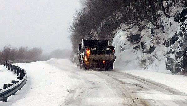
Photo by Suzanne Galyon
A truck from the Tennessee Department of Transportation was busy at mid-day Wednesday pushing snow on the Roan. Several inches of snow were reported on the Roan and it was still snowing. Schools in the area were out for a third straight day Friday due to snow-covered roads.
With snowfall predictions for this weekend’s forecast winter weather system ranging anywhere from a few inches to more than a foot, local officials are hoping residents are prepared to ride out the storm if it gets serious.
Carter County Emergency Management Agency Director Gary Smith is encouraging residents to prepare early so when the snow does arrive they will not have to drive out for supplies.
“We would really prefer you don’t drive if you don’t have to,” Smith said.
For those who must venture out, Smith recommends making sure the vehicle has plenty of fuel, a full tank if possible, as well as some other necessities.
“You definitely want to have blankets and coats in your vehicle,” he said.
To help prepare your home, Smith recommends putting together an emergency kit. An emergency kit should include a weather radio, flashlight, batteries for the radio and flashlight, plenty of drinking water, baby wipes, non-perishable food that does not need to be cooked, matches, candles and a few days supply of any essential medications.
For those who have an alternative heat source in the event of a power outage, Smith recommended making sure plenty of fuel for that heat source is available, whether it be a kerosene or propane heater or a wood stove.
Residents should also be prepared for the chance of power outages. “That is a possibility with any storm,” Smith said, adding the National Weather Service has forecast the possibility of ice with this storm system, which could increase the potential for power outages.
The county does have plans in place in the event an emergency shelter needs to be opened, Smith said. However, he added, that usually only occurs with a prolonged emergency event and the current forecast does not call for the storm to be long-lasting.
“If we have some folks that need shelter, one of the churches will open up for them,” Smith said.
On Thursday afternoon, Tennessee Governor Bill Haslam, at the request of the Tennessee Emergency Management Agency, declared a Level III State of Emergency in advance of the storm. An announcement of the declaration by TEMA said “the possible critical impacts from this weather system may lead to stranded motorists, power outages, and people needing shelter.”
According to the National Weather Service forecast, today was expected to begin with a wintry mix of sleet, freezing rain and snow.
“It will change over to all snow around 3 or 4 p.m.,” said NWS Meteorologist Jessica Winton. “The heaviest snow looks like it is going to be overnight Friday and into Saturday.”
Winton said Elizabethton can expect to see anywhere between 6-to-8 inches of snow while the higher elevations could expect to see 12-to-14 inches, possibly more. The system also has the potential to bring “strong mountain wave” winds to the area, Winton said, so snow drifting could occur, especially in the higher elevations.
The high temperature today is expected to reach around 31, which Winton said will happen in the early afternoon, before dropping into the lower 20s over night. On Saturday the temperature is expected to climb to the upper 20s before dropping into the middle-teens overnight on Saturday. Some snow is still possible early Sunday, but skies are expected to clear as the temperatures reach back up to the upper 30s.