Snow and sleet in the forecast for Thursday
Published 7:06 pm Wednesday, March 4, 2015
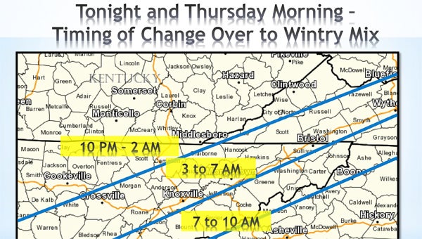
Graphic courtesy of the National Weather Service
Thursday’s forecast calls for the possibility of snow and ice for Carter County, but the storm may lose its steam before it gets here according to the National Weather Service.
“The heaviest accumulations will probably be on the west end of the plateau,” NWS Meteorologist Jessica Winton said. “It kind of loses steam by the time it gets to your area.”
Despite the loss of momentum, the winter weather system is still expected to bring up to 2 inches of snow to Carter County with the possibility of 3 to 4 inches in the higher elevations.
Also, Winton said, the system brings the potential for some ice accumulation as it first moves into the area. “It looks like there will be a little bit — maybe a tenth of an inch,” she said.
Rain will continue today, with the heaviest rainfall coming late in the evening, Winton said. Early Thursday morning, temperatures will begin to drop, which will allow the rain to change over first to sleet, then to freezing rain and eventually to snow.
“The high for the day on Thursday is actually going to be around midnight at about 44 or 45 degrees,” Winton said. “By 7 or 8 in the morning, the temperature will drop to about 34 or 35 degrees. In the early afternoon, around 1 or 2 p.m., the temperature will be in the upper 20s. It will be a slow decline in temperature throughout the day.
With the dropping temperatures, Winton said the precipitation is expected to change over to a rain and sleet mix around 5 or 6 a.m. and will become all snow by about 10 a.m. The transition from rain to all snow will take a few hours to occur, Winton said.
“It will be all snow for the rest of the afternoon,” Winton said, adding snow will fall most of the day and taper off in the evening. Most of the accumulation should occur early on, she added.
“It’s not going to be as bad as some of the others we’ve had but it wills till be bad enough to possibly cause some travel issues in the morning,” Winton said. “And, of course, any pets that are outside will need to come inside.”
Residents are advised to use caution when traveling Thursday morning as road conditions may deteriorate as the precipitation changes over, Winton said.
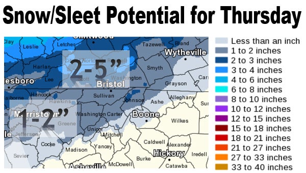
Graphic courtesy of the National Weather Service
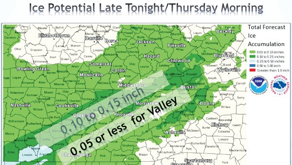
Graphic courtesy of the National Weather Service