Work underway to mark county’s Tweetsie Trail Expansion
Published 8:46 am Tuesday, June 28, 2016
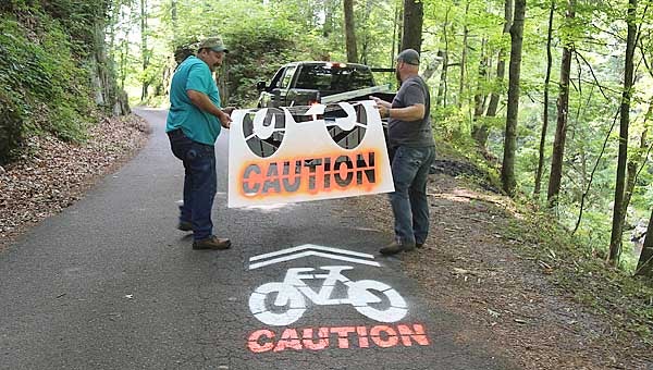
Star Photo/Abby Morris-Frye
Carter County Parks and Recreation Committee member Mel McKay, left, and Carter County Highway Committee Chairman Mike Hill remove a stencil from the road after a caution symbol was painted on Old Railroad Grade Road to advise motorists that bicyclists may be using the roadway. The markings are part of the county’s preparation for extending the Tweetsie Trail to Roan Mountain.
Work is underway to post signage and paint traffic markers along the path of the Carter County’s Tweetsie Extension which will extend the Tweetsie Trail from Elizabethton all the way to Roan Mountain.
In September, the Cities of Elizabethton and Johnson City celebrated the completion of the Tweetsie Trail. The following month, Carter County announced plans to extend the trail from where it currently stops at Hatcher Lane in Elizabethton to the Roan Mountain Community Park, which is located just behind the Roan Mountain Post Office on Highway 19E.
The extension has been a joint project between the Carter County Parks and Recreation Board, The Carter County Planning Office and the Carter County Highway Department. On Monday, Carter County Planning Director Chris Schuettler, Carter County Highway Committee Chairman Mike Hill, and Carter County Parks and Recreation Board Member Mel McKay were working to install signs along the trail extension marking the route and painting traffic markers on the roads to alert motorists to the presence of bicyclists.
In addition to putting up markers for “Carter County’s Tweetsie Extension,” the three men were putting up road signs marking the route for the Overmountain Victory Trail, a national historic trail which coincides with the route for the Tweetsie Extension. The OVT commemorates the route taken by patriots who mustered at Sycamore Shoals and then marched to Kings Mountain, S.C., where they assisted in the defeat of British forces during the American Revolution.
The route for the county’s Tweetsie Extension follows the line of the old Tweetsie Railroad as closely as is practical using existing roads.
The expansion of the Trail from Hatcher Lane to the Roan Mountain Community Park will add 16.5 miles to the Trail, bringing its overall length to 26.5 miles. By comparison, the popular Virginia Creeper Trail in southwest Virginia is 35 miles long.
However, while the portion of the Tweetsie Trail is constructed of crusher run gravel on gently sloping land, the county’s expansion will be a totally different experience as it climbs up to Roan Mountain.
From Hatcher Lane, the route for the Extension will follow Stateline Road to Highway 19E. The Extension will proceed along 19E into Hampton, where it will turn onto Rittertown Road, which is already a state-designated bike route.
The Tweetsie Extension will then travel the length of Rittertown Road and return to 19E just above Hampton. The Trail will once again follow 19E for a distance before turning onto Bear Cage Road just beyond the Tiger Creek Community.
Bear Cage Road will lead cyclists to the Doe River, just above the southern entrance to the Doe River Gorge. After crossing the river, the Trail will follow Old Railroad Grade Road along the river to the road’s end near Roan Mountain. The Trail will then cross over 19E onto Crabtree Road and follow it until it rejoins the highway. From there, the Trail will continue along 19E all the way to the Roan Mountain Community Park.
Not only is the riding surface much different for the Extension than it is for the existing Tweetsie Trail, the ride itself is more difficult as cyclists must navigate roads being traveled by cars and trucks while riding up steep inclines and navigating narrow back roads.
The Tweetsie Extension route will, by necessity, bypass what was considered to be one of the most scenic portions of the old Tweetsie Railroad — the Doe River Gorge.
“We studied the situation very carefully and reluctantly concluded that there was no way to do it,” Carter County Parks and Recreation Board Chairman Ken Gough said when the expansion was announced. “We won’t risk disrupting the operations of Doe River Gorge Christian Camp, and a large landowner has stated flatly that he will not give us a right of way. We can’t and won’t go through the Gorge without everyone’s cooperation.”
While cyclists on the Extension will miss out on the Gorge, they will be able to follow a part of the historic rail line for four miles along Old Railroad Grade Road, which was built on the old rail bed. That stretch of road is noted for its beauty and is often compared to the Virginia Creeper Trail.
Once all the signs and road markings are in place, the Parks and Recreation Board plans a formal announcement of the completion of the project. However, cyclists can already enjoy the ride in the meantime since the route is already in existence on public roads.